![]()
Industrial Geography: Understanding the Spatial Dynamics of Manufacturing and Services

Introduction
Industrial Geography sits at the intersection of space, economy, and human decision-making, helping us understand why factories, industries, and service centers emerge where they do and how their locations shape regional development. In a world where supply chains stretch across continents and digital services operate without physical boundaries, the spatial dynamics of production have become more complex than ever.
Today, both manufacturing and service industries rely heavily on strategic location choices to reduce costs, access markets, attract skilled labour, and remain competitive. The result is a constantly evolving industrial landscape that reflects technological change, transportation networks, government policies, and the socio-economic character of regions.
What is Industrial Geography
Industrial Geography is a branch of economic geography that examines how and why industries, both manufacturing and services, are distributed across space. It explores the relationships between industrial activities, their surrounding environments, and the networks that connect them.
At its core, industrial geography asks three fundamental questions:
Where are industries located? Why are they located there? And how do their spatial patterns influence economic development?
By analyzing these patterns, geographers gain insights into cost structures, market accessibility, transport efficiencies, labour dynamics, government incentives, and the evolution of industrial clusters.
The result is a clearer understanding of how spatial decisions shape the competitiveness and growth of both regional and global economies.
The Spatial Logic of Manufacturing
Manufacturing industries tend to follow a spatial logic rooted in cost optimization, resource accessibility, and logistical efficiency. Classic industrial location theories, such as Alfred Weber’s Least-Cost Theory, highlight how firms attempt to minimize transportation costs, labour expenses, and production challenges by locating strategically within a region. In practice, this means manufacturers often cluster near raw material sources, major markets, transport corridors, or energy supplies.
Over time, these initial choices give rise to industrial districts and specialized hubs where supporting industries, skilled labour, and shared infrastructure create strong agglomeration economies. As technology advances and global supply chains expand, new variables such as automation, connectivity, and government policies also influence where production activities choose to settle.
To understand this spatial logic of manufacturing better, check out: 4 Theories and Principles of Settlements

Case Example: Aba Manufacturing Hub (Nigeria)
Aba offers one of the most vivid examples of how manufacturing clusters emerge organically in response to local needs, skills, and market opportunities. Known widely as the “Japan of Africa,” Aba has developed a reputation for its vibrant network of artisans, small-scale manufacturers, and traders who specialize in leatherwork, fashion, metal fabrication, and household items.
What makes Aba’s industrial landscape unique is its combination of dense commercial activity, accessible road networks, and the presence of massive markets like Ariaria International Market that serve as both production centers and distribution hubs. Despite limited formal planning, the city’s industrial clusters have grown through strong social networks, shared knowledge, and a culture of innovation that allows micro and small enterprises to thrive in a highly competitive environment.
This spatial concentration continues to shape economic opportunities in southeastern Nigeria.
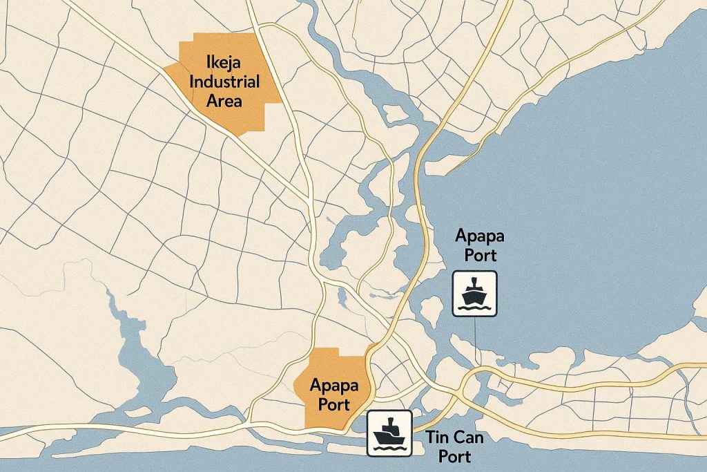
Lagos Industrial Clusters (Nigeria)
Lagos represents a more formal and large-scale expression of industrial clustering, shaped by its strategic coastal location, extensive transport networks, and role as Nigeria’s primary economic gateway. The city hosts several major industrial estates such as Ikeja Industrial Estate, Ilupeju, Apapa, and the fast-growing Agbara and Lekki Free Zone corridors, each designed to accommodate medium to large manufacturing firms with access to ports, airports, highways, and distribution networks.
These clusters attract companies involved in food processing, pharmaceuticals, textiles, construction materials, and consumer goods, creating a dense ecosystem of suppliers, distributors, and logistics providers. The presence of the Apapa and Tin Can Island Ports further enhances Lagos’s industrial appeal by reducing export and import bottlenecks for firms that rely on global supply chains.
Over the years, government incentives, public-private infrastructure investments, and market proximity have continued to reinforce Lagos as the country’s dominant industrial hub, influencing production patterns nationwide.
Global Case Studies
Industrial geography is not limited to Nigeria, and global examples provide important lessons on spatial dynamics. Silicon Valley in the United States illustrates how service-oriented tech industries cluster to benefit from talent, venture capital, and knowledge spillovers. Similarly, Germany’s Ruhr region demonstrates the traditional manufacturing model, where coal, steel, and heavy industry created dense industrial corridors supported by transport networks and urban centers.
In East Asia, special economic zones in China, such as Shenzhen, show how government policy, infrastructure investment, and global trade integration can rapidly transform regional industrial landscapes. Each of these examples highlights how strategic location, agglomeration economies, and connectivity influence the growth and competitiveness of both manufacturing and service industries.
By comparing global and Nigerian contexts, geographers and planners can better understand patterns, challenges, and opportunities in modern industrial development.

GIS Methods in Industrial Geography
Buffer Analysis
Buffer analysis is a fundamental GIS technique that creates zones around specific features, such as factories, roads, or markets, to study their influence on surrounding areas. In industrial geography, buffers can reveal which residential areas, transport hubs, or suppliers fall within a specific distance of a manufacturing site.
This helps in understanding market reach, accessibility, and potential environmental impact. For example, when analyzing Aba’s leather and fashion clusters, buffer analysis can show which neighbourhoods and transportation links are most affected by industrial activities. Buffering is also useful in planning infrastructure improvements or siting new facilities.
Network Analysis
Network analysis evaluates how goods, services, or people move across transport systems such as roads, railways, or ports. In industrial geography, it helps determine optimal routes for supply chains, the efficiency of logistics networks, and travel time between production sites and markets.
For instance, mapping the Lagos industrial corridors using network analysis can identify bottlenecks in port access or major highways, allowing planners to optimize distribution. This method also assists in strategic facility placement by highlighting areas with minimal travel costs and maximum connectivity to suppliers, customers, and labour markets.
Hotspot Analysis
Hotspot analysis identifies areas with unusually high or low concentrations of industrial activity. By using spatial statistics in GIS, geographers can pinpoint clusters of manufacturing or service firms, highlighting where economic activity is densest.
For example, applying hotspot analysis to Lagos can reveal the most active industrial zones, guiding policy-makers on where to invest in infrastructure or incentives.
In Aba, hotspot maps can uncover areas where small-scale industries are concentrated, helping planners understand growth patterns and competitive dynamics. This method is invaluable for both urban planning and strategic business decision-making in industrial geography.
Interpolation
Interpolation is a GIS technique used to estimate values at unsampled locations based on known data points. In industrial geography, it can predict variables such as population density, labour availability, or transport accessibility across a region.
For instance, interpolating workforce density around Lagos and Aba industrial clusters allows planners and businesses to estimate potential labour pools for new facilities.
Similarly, interpolating transport times or service accessibility helps identify underserved areas and optimize site selection. Interpolation provides a spatially continuous understanding of industrial factors, making decision-making more data-driven and precise.
Suitability Analysis
Suitability analysis evaluates the best locations for industrial development by integrating multiple spatial criteria, such as land availability, proximity to roads, utilities, and markets.
Using GIS, geographers assign weights to each factor, producing maps that highlight ideal sites for factories, warehouses, or service centers. In Nigeria, suitability analysis can support planning for new industrial estates in Lagos, Aba, or other emerging hubs.
It also assists investors in minimizing costs and maximizing efficiency by identifying locations that balance accessibility, resource availability, and environmental constraints. This method bridges spatial data with practical industrial decision-making.
My practical experience with GIS methods in industrial geography took place in Calabar, where we applied buffer analysis, network mapping, hotspot studies, interpolation, and suitability analysis using a sample location provided by our lecturer.
In groups, we were sent to field locations along Flour Mill Highway and Marian Road to collect and analyze data under tight deadlines and the scotching sun. Although the work was physically demanding and stressful, it provided invaluable hands-on insights into industrial spatial patterns.
Experiencing firsthand how clusters form, transport accessibility impacts industrial activity, and spatial analysis informs decision-making made the theoretical concepts much more tangible and rewarding.
Spatial Dynamics of the Service Economy
The service economy exhibits distinct spatial patterns compared to manufacturing, yet it is equally shaped by location, connectivity, and clustering. Banking, telecommunications, IT services, and professional offices often concentrate in urban centers where skilled labour, infrastructure, and clients are readily available.
In Nigeria, Lagos and Abuja illustrate this dynamic, hosting financial districts, tech hubs like Yaba, and corporate headquarters. Globally, cities such as New York, London, and Singapore show similar trends, with high-value services clustering to maximize efficiency and knowledge sharing.
Understanding these spatial dynamics allows planners and businesses to optimize service accessibility, urban zoning, and the integration of technology-driven solutions into regional economies.
Industrial Geography in Nigeria: Opportunities & Challenges
Nigeria has significant opportunities for industrial growth due to its large population, abundant natural resources, and strategic geographic location. Major cities like Lagos, Aba, and Port Harcourt demonstrate how industrial clusters can drive economic development, attract investment, and create employment.
However, challenges such as inconsistent government policies, poor infrastructure, and uneven regional development often limit the country’s industrial potential. Industrial zones outside major hubs struggle with connectivity, utilities, and planning support, which can discourage investors.
Regions such as Cross River State and Akwa Ibom illustrate this underutilization. During field exercises in 2023, some quarry sites in Akamkpa Local Government Area, particularly in Obung and nearby communities, were observed to have been abandoned.
Similarly, Akwa Ibom has untapped opportunities in minerals and small-scale manufacturing that remain underdeveloped. These examples highlight the need for better spatial planning, strategic infrastructure investment, and the application of GIS tools to identify suitable industrial locations.
Leveraging these strategies could help diversify Nigeria’s industrial landscape and unlock the economic potential of currently underutilised regions.
Future Trends in Industrial Geography
The future of industrial geography will increasingly be shaped by technology, data-driven planning, and global economic shifts. Automation and Industry 4.0 are changing manufacturing location decisions, as proximity to labour becomes less critical and access to digital infrastructure grows in importance.
Smart logistics, enabled by real-time data and GIS, allows firms to optimise supply chains, reduce costs, and respond quickly to market fluctuations. Remote sensing and big data analytics are also enhancing spatial analysis, helping policymakers identify potential industrial zones and plan infrastructure more effectively.
In Nigeria, integrating these tools could support the development of underutilised regions, improve industrial resilience, and encourage sustainable growth. Globally, the trend toward knowledge-based economies emphasises clustering of high-value services, innovation hubs, and green industries.
Industrial geography, combined with GIS expertise, will continue to play a crucial role in guiding investment, shaping urban and regional planning, and predicting the evolution of manufacturing and service networks.
Conclusion
Industrial geography provides invaluable insights into how manufacturing and service industries are distributed across space and how these patterns shape economic development. By combining traditional location theories with modern GIS methods, geographers can analyze clusters, optimize supply chains, and identify untapped regional potential.
Nigerian examples such as Aba and Lagos demonstrate both the opportunities and challenges of industrial development, while global cases illustrate how connectivity, policy, and innovation drive competitiveness.
Applying GIS in fieldwork, even under challenging conditions as experienced in Calabar, shows the practical value of spatial analysis in understanding real-world industrial dynamics. Looking forward, technology, data-driven planning, and strategic investments will further influence where industries locate and thrive.
Recognizing these spatial dynamics is essential for policymakers, investors, and planners seeking to foster sustainable, efficient, and equitable industrial growth in Nigeria and beyond.
Our quiz will soon be made ready to test your knowledge of industrial geography.
References / Sources
-
Akamkpa Quarry Sector Investments – Progressive News
-
Lagos Industrial Estate Information – Lagos State Government
-
Global Industrial Clusters Overview – World Bank

Idara Eniang is a passionate digital creator and geographer dedicated to making geography simple, visual, and accessible.


