![]()
Land Area Measurement in Geography: Meaning, Units, and Importance
Land area measurement is a fundamental concept in geography that helps us understand how space is organized, used, and managed on the Earth’s surface. From farms and cities to forests and protected areas, measuring land area allows geographers, planners, and students to compare places, analyze patterns, and make informed decisions about land use and development.
Despite its importance, land measurement is often misunderstood, especially outside the classroom. Terms such as plot, acre, or hectare are commonly used, yet many people struggle to visualize what these measurements actually represent in real life. This gap between numbers and understanding can lead to confusion in education, environmental studies, and even everyday situations like buying land.
This article explains what land area measurement means in geography, why it matters, the common units used, and how land size is measured and interpreted. It also introduces ways to better understand land area through visual and practical examples, forming the foundation for deeper learning in this land measurement series.
What Is Land Area Measurement?
Land area measurement refers to the process of determining the amount of surface space that a piece of land covers. In geography, it focuses on measuring land in two dimensions, length and width combined, to calculate the total area of a place. This area is usually expressed using standardized units such as square meters, hectares, or square kilometers, depending on the size of the land being measured.
Unlike distance, which measures how far apart two points are, land area measurement describes how much space exists within defined boundaries. For example, measuring the length of a road tells us how far it stretches, but measuring the area of a farmland tells us how much space is available for cultivation. This distinction is important because many geographic decisions, such as land use planning, population density analysis, and environmental management, depend on area rather than distance.
In geography, land area measurement is used to compare places, analyze spatial patterns, and understand how land is distributed across regions. Whether it is the size of a country, a city, a forest reserve, or a school compound, measuring land area helps geographers describe and interpret the physical and human features of the Earth in a consistent and meaningful way.
Why Land Area Measurement Is Important in Geography
Land area measurement plays a central role in geography because it provides a reliable way to understand how space is used, shared, and managed. Many geographic questions cannot be answered without knowing the size of the land involved. From local communities to entire countries, accurate land area measurement supports analysis, planning, and decision-making.
Agriculture and Land Use Planning
In agricultural geography, land area measurement helps determine how much land is available for farming, how crops should be distributed, and how productive a piece of land can be. Farmers and planners rely on land size information to estimate yields, manage irrigation, and plan sustainable land use practices.
Urban and Regional Planning
Cities and settlements grow within limited space. Measuring land area allows urban planners and geographers to design housing layouts, road networks, and public facilities efficiently. It also helps in analyzing population density, land availability, and patterns of urban expansion.
Environmental Management and Conservation
Environmental geographers use land area measurement to study forests, wetlands, wildlife reserves, and other natural ecosystems. Knowing the size of protected areas helps in conservation planning, monitoring environmental change, and assessing the impact of human activities on natural landscapes.
Geography Education and Research
In geography education, land area measurement is essential for understanding maps, interpreting spatial data, and comparing regions. It allows students and researchers to analyze geographic patterns accurately and develop strong spatial thinking skills.
Common Units Used in Land Area Measurement
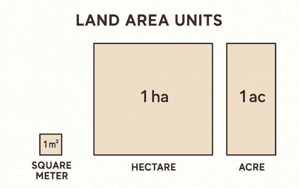
Land area measurement in geography relies on standardized units that allow places to be measured, compared, and analyzed accurately. Different units are used depending on the size of the land being measured, ranging from small plots to entire countries. Understanding these units helps reduce confusion and improves the interpretation of maps and geographic data.
One of the most commonly used units is the square meter (m²). It is the basic unit for measuring land area and is often used for small spaces such as rooms, building plots, or school compounds. Because of its precision, the square meter serves as the foundation for many larger land measurement units.
For larger areas, geographers often use the hectare. One hectare is equal to 10,000 square meters and is widely used in agriculture, forestry, and environmental studies. It provides a practical way to describe farmland, parks, and forest reserves without dealing with very large numbers.
The acre is another commonly used land measurement unit, especially in real estate and land transactions in some countries. Although it is not part of the metric system, it remains widely recognized. Because acres are defined differently from metric units, misunderstandings can occur when land sizes are compared across regions.
For very large areas such as cities, regions, or countries, the square kilometer (km²) is typically used. This unit allows geographers to measure and compare extensive land areas in a clear and manageable way.
Because multiple units are used globally, land area measurement can sometimes feel confusing. A dedicated article in this series explores these units in detail and explains how they relate to one another through simple conversions and examples.
Local and Informal Land Measurement Terms
In everyday conversations, land is often described using informal or local terms rather than standard measurement units. While these terms are widely understood within communities, they can create confusion when used in geographic analysis or land comparison.
What Does “A Plot of Land” Mean?
The term plot is commonly used in many countries, including Nigeria, to describe a piece of land intended for building or ownership. However, a plot does not have a fixed or universal size. The actual area of a plot can vary depending on location, land layout, and local planning standards. For example, a plot in an urban area may be much smaller than a plot in a rural community.
Because of this variation, using plots as a unit of measurement can be misleading. Two plots in different locations may represent very different land sizes, even though they are described using the same term.
Why Geography Uses Standard Measurement Units
In geography, accuracy and comparability are essential. Standard units such as square meters, hectares, and square kilometers allow land areas to be measured consistently, regardless of location. These units make it possible to compare land sizes across regions, analyze spatial patterns, and produce reliable maps and geographic data.
While informal terms like plot are useful in everyday communication, geographic studies rely on standardized land area measurement to avoid ambiguity and ensure clarity. Understanding this difference helps bridge the gap between local land descriptions and scientific geographic analysis.
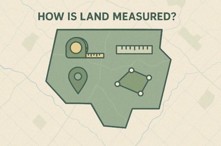
How Land Area Is Measured in Geography
In geography and environmental studies, land area is measured using systematic methods that ensure accuracy, consistency, and repeatability. Unlike informal descriptions, these methods rely on defined boundaries, coordinate systems, and measurement tools to calculate land size precisely.
1. Field-Based Measurement Methods
Traditional land measurement begins with direct field techniques. These involve physically measuring boundaries using tools such as measuring tapes, chains, or survey equipment. While this approach can be accurate for small parcels of land, it becomes time-consuming and impractical for large areas or difficult terrain.
Field-based measurements are commonly used in local land surveys and small-scale land demarcation but are rarely sufficient for regional or national geographic analysis.
2. Map-Based Measurement
Geographers often measure land area using maps with known scales. By tracing land boundaries on a map and applying the map scale, the real-world area can be calculated. This method is useful for educational purposes and preliminary analysis but depends heavily on map accuracy and proper scaling.
Map-based measurement helps students and beginners understand how land size relates to real-world distances.
3. GIS and Digital Measurement
Modern geography relies heavily on Geographic Information Systems (GIS) to measure land area. GIS software such as QGIS and ArcGIS allows users to define boundaries digitally, apply coordinate reference systems, and automatically calculate area in standard units.
This method is highly accurate and scalable, making it suitable for land management, environmental studies, urban planning, and academic research.
4. Satellite Imagery and Remote Sensing
Large-scale land areas are often measured using satellite imagery. By analyzing high-resolution images and spatial data, geographers can calculate land size across vast regions without physical access to the land.
Remote sensing is especially important for studying forests, wetlands, agricultural land, and protected areas.
Why Measurement Method Matters
The method used to measure land affects accuracy, interpretation, and usability of the results. Choosing the right approach depends on land size, purpose, available tools, and required precision. Understanding these methods helps learners move from informal land descriptions to reliable geographic measurement.
Why People Often Misunderstand Land Size
Land size is one of the most misunderstood concepts in geography, especially among first-time land buyers, students, and non-technical users. The confusion often comes from a mix of informal language, poor visualization, and a lack of standardized measurement knowledge.
1. Reliance on Local and Informal Terms
Many people describe land using local terms such as “a plot,” “half plot,” or “two plots” without knowing the actual land area in standard units. Since the size of a “plot” can vary widely between regions, this leads to assumptions that are often incorrect.
2. Difficulty Visualizing Area
Numbers like square meters, hectares, or acres are abstract to most people. Without a visual reference, it is hard to imagine how large or small a piece of land actually is. This makes it easy to underestimate or overestimate land size when making decisions.
3. Confusing Length With Area
A common mistake is assuming that land with long boundaries is large in area. In reality, land shape plays a major role. Two lands with the same perimeter can have very different areas, which often surprises people unfamiliar with geographic measurement.
4. Lack of Exposure to Measurement Tools
Most people have never used maps, GIS tools, or digital measurement platforms. As a result, they rely on verbal descriptions or rough estimates instead of accurate measurements.
5. Real-World Consequences
Misunderstanding land size can lead to poor purchasing decisions, disputes, inefficient land use, and financial loss. This is why learning how land area is measured and visualized is essential, not just academically but practically.
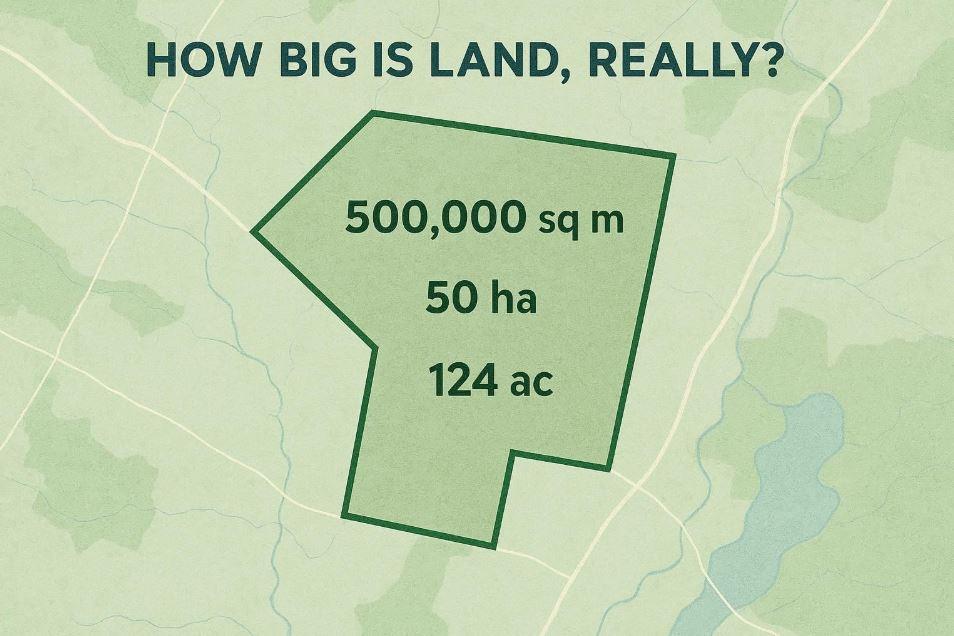
Understanding Land Area Through Visual Comparison
One of the most effective ways to understand land area is through visual comparison. Humans understand space better when measurements are linked to places they already recognize, rather than abstract numbers alone. Seeing how large a piece of land is in relation to familiar environments helps turn confusing figures into something meaningful.
Why Visual Comparison Improves Understanding
Land measurements such as square meters or hectares can feel abstract, especially to beginners. Visual comparison helps the brain translate numbers into real-world space, making it easier to judge size, proportion, and scale accurately.
Using Familiar Places to Explain Land Size
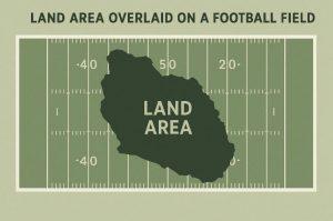
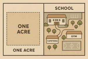
Relating land area to everyday locations allows learners to quickly grasp scale. Instead of memorizing figures, people can imagine how much space is actually involved.
Common reference points include:
-
Football fields, which provide a clear sense of a large open space
-
School compounds, which many people are familiar with from daily life
-
City landmarks, such as parks or public squares, that offer a strong spatial context
Making Land Measurement Easier to Learn
Visual tools that compare land sizes with recognizable locations can greatly improve understanding, especially for students, first-time land buyers, and beginners in geography. By linking measurements to familiar spaces, land area becomes easier to interpret and remember.
Applications of Land Area Measurement
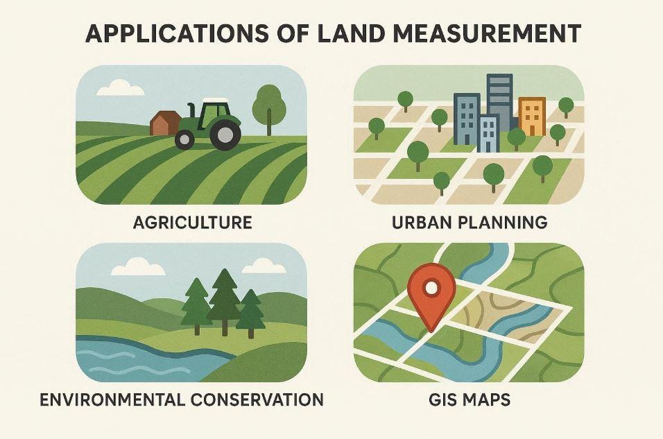
Understanding land area measurement is essential across many fields where space, resources, and planning matter. In geography, accurate land measurement supports informed decision-making and sustainable land use.
-
Agriculture: Farmers use land area measurements to plan crop spacing, estimate yield, manage irrigation, and apply fertilizers efficiently.
-
Real Estate: Accurate land size helps buyers, sellers, and developers determine property value, compare plots, and avoid disputes.
-
Environmental Management: Land measurement is used to monitor forests, wetlands, protected areas, and land-use change over time.
-
Urban Planning: City planners rely on land area data to design roads, housing layouts, public facilities, and infrastructure.
-
GIS and Mapping: Geographic Information Systems use precise area measurements for spatial analysis, mapping, and decision support.
-
Geography Education: Students use land area measurement to understand scale, spatial relationships, and real-world applications of geography.
Common Land Measurement Mistakes (And How to Avoid Them)
Many land measurement errors come from misunderstanding scale, units, or boundaries. A common mistake is relying on local terms like “plot” without confirming the actual area in standard units. Another issue is confusing length with area, assuming long boundaries mean a large land size. Using the wrong coordinate reference system (CRS) in digital tools can also produce incorrect results. These mistakes can be avoided by using standardized units, verified maps, and reliable GIS tools when measuring land.
Learn More: Related Geography Resources
To deepen your understanding of land area measurement and related topics, explore these helpful resources on Simply Geography:
-
Coordinate Reference Systems Explained (CRS Guide) (recommended for accurate measurements)
-
Land Measurement Methods and Tools (related posts in this series)
These resources help bridge theory with practical application.
Conclusion: Making Sense of Land Area in Geography
Land area measurement is a foundational concept in geography that affects agriculture, real estate, environmental management, and education. Understanding standard units, measurement methods, and common mistakes helps learners move beyond assumptions and make informed decisions. With clear explanations and real-world comparisons, land measurement becomes easier to understand and apply. As geography continues to evolve with digital tools, learning how land is measured remains an essential skill for students and professionals alike.

Idara Eniang is a passionate digital creator and geographer dedicated to making geography simple, visual, and accessible.