![]()
How to Measure Land Area: Methods, Tools, and Practical Examples

Knowing how to measure land area is an essential skill in geography, land management, and everyday decision-making. Whether you are a student, a first-time land buyer, or someone working with maps and spatial data, understanding the different ways land can be measured helps you avoid costly mistakes and confusion.
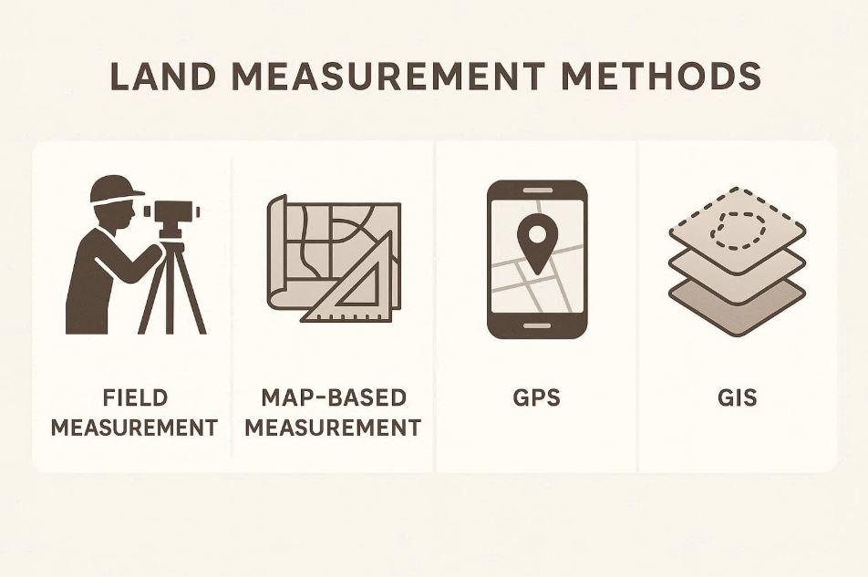
Land measurement is not done using a single method. Depending on the size of the land, the purpose of the measurement, and the tools available, land area can be measured using simple field techniques, map-based methods, GPS devices, or digital tools like Geographic Information Systems (GIS). Each method has its strengths and limitations.
In this guide, you will learn the most common land measurement methods used in geography, how they work, and when to use each one. If you are new to land measurement, you may also want to read our complete guide on land area measurement in geography to understand the basic concepts before continuing.
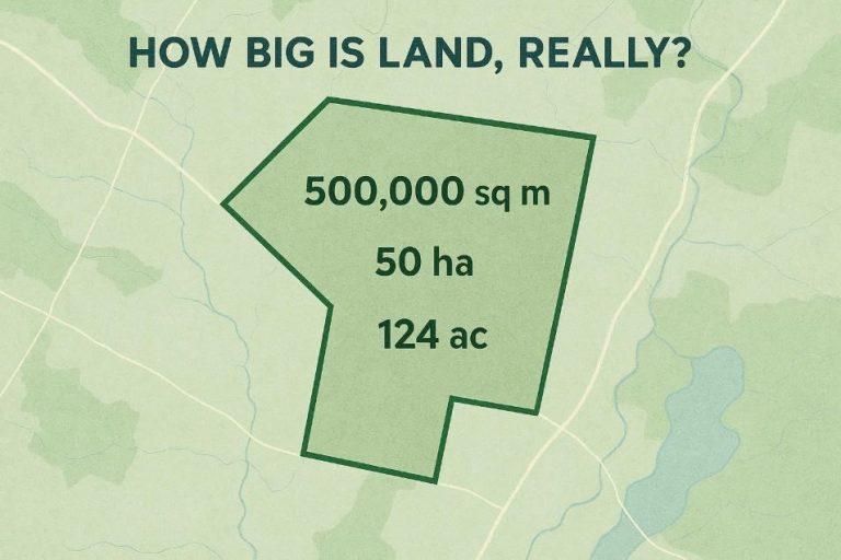
Understanding Land Boundaries Before Measurement
Before measuring any piece of land, it is important to clearly understand its boundaries. Land boundaries define the exact extent of an area and determine what is included or excluded during measurement. Without clear boundaries, even the most accurate measurement tools can produce misleading results.
What Are Land Boundaries?
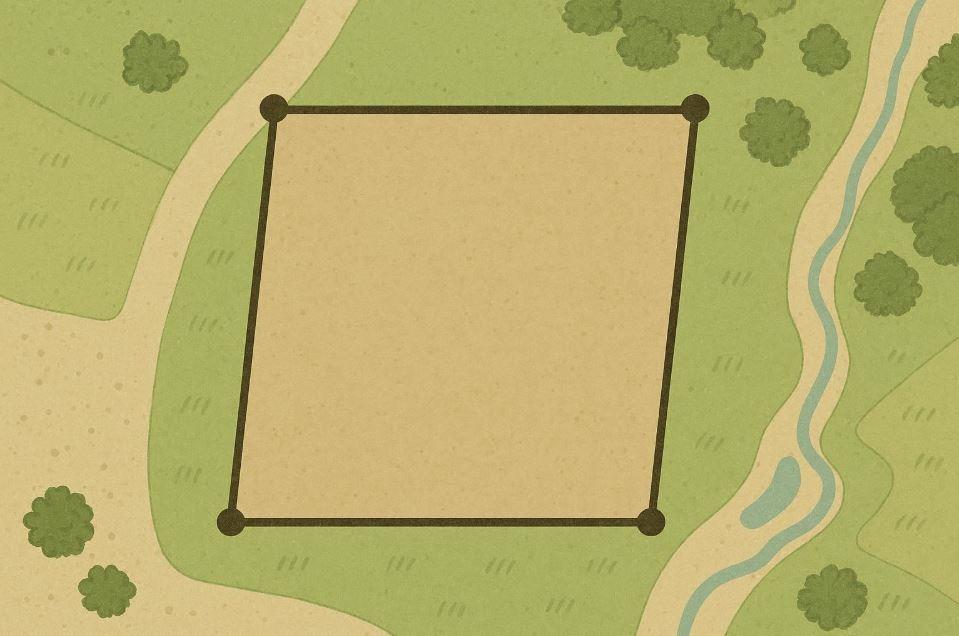
Land boundaries are the defined lines that separate one parcel of land from another. These boundaries may be physical, such as fences or walls, or invisible, defined using coordinates and survey records. In geography, boundaries are usually represented as closed shapes that outline an area on a map.
Physical vs Legal Boundaries
Physical boundaries are features you can see on the ground, such as fences, roads, rivers, or hedges. Legal boundaries, on the other hand, are officially recorded in land documents and maps. These may not always match visible features on the land, which is why relying only on physical markers can be misleading.
Why Boundaries Matter in Land Measurement
Accurate land measurement depends on correctly identifying the boundary lines. Measuring beyond or within incorrect limits can lead to overestimation or underestimation of land size. This is a common source of land disputes and valuation errors.
How Boundaries Are Represented Digitally
In digital mapping and GIS, land boundaries are drawn as polygons using coordinate points. These polygons allow software to calculate land area accurately once the correct coordinate reference system (CRS) is applied.
Understanding land boundaries is the foundation of reliable land measurement. Once boundaries are clearly identified, different measurement methods can be applied with confidence.
Measuring Land Using Simple Field Methods
Simple field methods are the most basic ways of measuring land area. These methods involve direct measurement on the ground using simple tools and are often used for small parcels of land, rough estimates, or educational purposes. While they can provide useful approximations, they are not always suitable for high-precision or legal measurements.
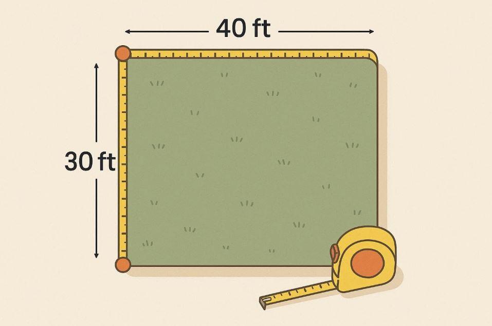
Measuring with Tapes and Chains
One of the oldest field methods involves measuring land boundaries using measuring tapes or survey chains. The length of each side of the land is measured, and the area is calculated based on the shape of the parcel. This method works best for rectangular or regularly shaped land.
Although fairly accurate for small areas, this approach becomes time-consuming and difficult for large or irregular land parcels.
Pacing Method (Rough Estimation)
The pacing method involves estimating distance by counting steps and multiplying by an average step length. This method is commonly used for quick, informal assessments when tools are not available.
Pacing is easy to apply but highly approximate. Differences in stride length, terrain, and human error make it unsuitable for precise measurement.
Strengths and Limitations of Field Methods
Field methods are simple, inexpensive, and easy to understand, making them useful for beginners. However, they are affected by terrain, obstacles, and human error. For this reason, they are best used for small-scale measurements, learning purposes, or preliminary assessments rather than official land documentation.
Measuring Land Using Maps and Scale
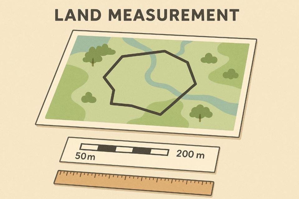
Maps provide a practical way to measure land area without physically visiting the site. By using a map with a known scale, geographers can estimate real-world distances and calculate land area accurately, especially for educational and planning purposes.
What Is Map Scale?
Map scale shows the relationship between distances on a map and their actual distances on the ground. It is usually expressed as a ratio (for example, 1:50,000) or as a scale bar. Understanding map scale is essential because it determines how measurements taken on the map translate into real-world values.
How Land Area Is Measured on Maps
To measure land area using a map, the land boundary is traced on the map and its dimensions are measured using the map scale. These measurements are then converted into real-world units such as square meters or hectares. This method works best when the map is accurate and the land boundaries are clearly defined.
Advantages of Map-Based Measurement
Map-based measurement allows users to estimate land size over large areas and inaccessible locations. It is cost-effective and useful for academic study, planning, and preliminary analysis.
Limitations of Map-Based Measurement
The accuracy of this method depends on map quality, scale, and correct interpretation. Errors can occur if the map scale is misunderstood or if the map projection introduces distortion. For this reason, map-based measurements are best used for estimates rather than legal or engineering purposes.
Understanding how to use map scale correctly helps bridge the gap between simple field methods and advanced digital measurement tools.
Measuring Land Digitally Using GIS Tools
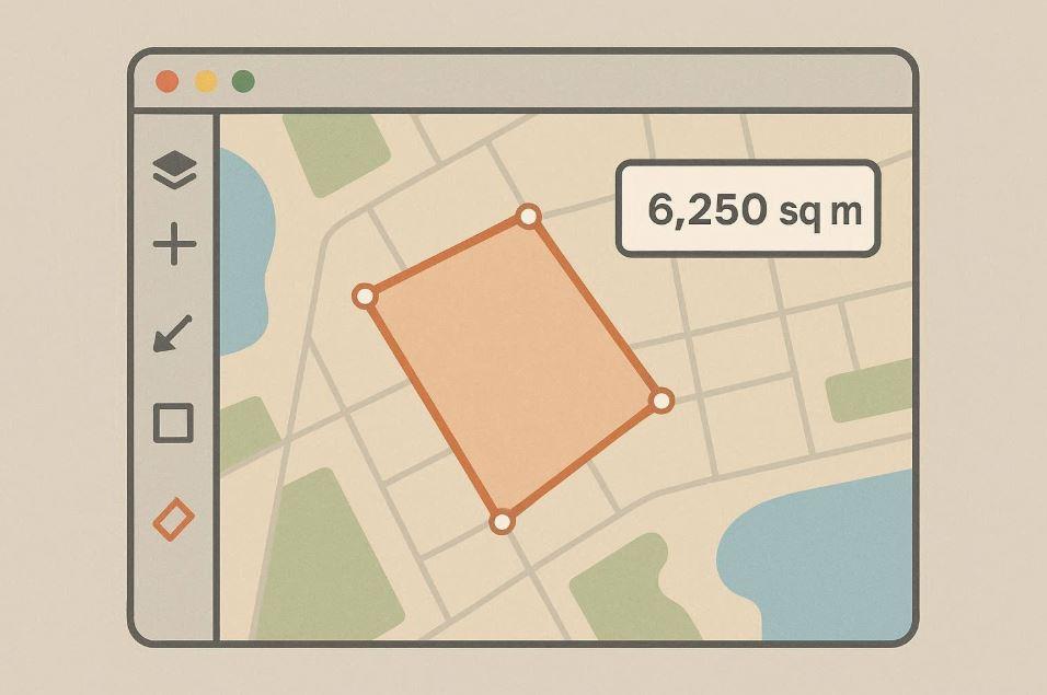
Geographic Information Systems (GIS) provide one of the most accurate and efficient ways to measure land area. Unlike field or map-based methods, GIS allows land boundaries to be defined digitally and measured automatically using spatial data and coordinate systems.
What Is GIS Land Measurement?
In GIS, land area is measured by drawing or importing land boundaries as digital shapes called polygons. Once a polygon is created, the software calculates the area based on the selected coordinate reference system (CRS). This makes GIS measurement both precise and repeatable.
Popular GIS Software for Land Measurement
Widely used GIS tools such as QGIS and ArcGIS allow users to measure land area using built-in measurement tools. These platforms support different map layers, shapefiles, and projections, making them suitable for educational, environmental, and planning applications.
Importance of Coordinate Reference Systems (CRS)
Accurate GIS measurement depends on using the correct CRS. Measuring land in the wrong projection can lead to incorrect area values. This is why understanding CRS is essential when working with digital land measurement tools.
Advantages of GIS-Based Measurement
GIS tools can handle large and irregular land parcels, provide consistent results, and allow easy conversion between units such as square meters, hectares, and acres. They are widely used in land management, environmental studies, and geographic research.
For beginners, learning GIS-based measurement provides a strong foundation for modern geographic analysis and prepares users to work confidently with spatial data.
Measuring Land with GPS and Mobile Devices
GPS technology offers a convenient way to measure land area without traditional surveying tools. By using satellites to determine location, GPS devices can record boundary points and calculate land size digitally. This method is increasingly popular due to its accessibility and ease of use.
How GPS Land Measurement Works
GPS-based measurement involves walking around the boundary of a land parcel while recording coordinate points. These points are then connected to form a closed shape, allowing the land area to be calculated automatically. This process can be done using handheld GPS devices or mobile applications.
Using Smartphones for Land Measurement
Many mobile apps allow users to measure land using smartphone GPS. These tools are useful for rough estimates, educational purposes, and quick assessments. However, smartphone GPS accuracy can vary due to signal strength, device quality, and environmental conditions.
Accuracy Considerations
GPS measurements are generally more accurate than pacing or tape methods but less precise than professional survey equipment or GIS-based analysis. Factors such as satellite visibility, terrain, and user movement can affect results.
When GPS Measurement Is Appropriate
GPS and mobile methods are suitable for preliminary land assessment, learning, and informal planning. For legal, engineering, or high-precision needs, professionally surveyed or GIS-verified measurements are recommended.
Understanding the strengths and limitations of GPS-based measurement helps users choose the right tool for their land measurement needs.
Comparing Land Measurement Methods
Different land measurement methods serve different purposes. The best method depends on the size of the land, the required accuracy, and the tools available. Understanding how these methods compare helps users choose the most suitable approach for their needs.
Accuracy
Field methods and pacing provide rough estimates and are more prone to human error. Map-based measurement offers moderate accuracy when map scale and projection are properly understood. GIS tools provide high accuracy, especially when the correct coordinate reference system is used. GPS and mobile devices fall between map-based and GIS methods in terms of precision.
Cost and Accessibility
Field methods and mobile GPS apps are low-cost and easy to access. Map-based measurement requires access to reliable maps. GIS tools may require learning software but are often free or affordable, especially with open-source options like QGIS.
Skill Level Required
Simple field methods require little technical skill. Map-based measurement needs basic map-reading knowledge. GIS and GPS-based methods require some familiarity with digital tools but offer greater reliability once learned.
Best Use Cases
Field methods are suitable for small plots and learning purposes. Map-based measurement works well for academic study and planning. GPS methods are useful for quick assessments in the field. GIS-based measurement is best for accurate analysis, documentation, and large or irregular land parcels.
Comparing these methods helps users avoid unnecessary complexity while still achieving reliable land measurements.
Common Land Measurement Mistakes (And How to Avoid Them)
Many land measurement errors occur due to misunderstanding tools, units, or boundaries. Being aware of these common mistakes helps prevent inaccurate results and costly decisions.
Using Informal or Assumed Land Sizes
Relying on local terms such as “plot” without confirming the actual land area often leads to incorrect assumptions. Always verify land size using standard units like square meters, hectares, or acres.
Ignoring Boundaries
Measuring land without clearly identifying its boundaries can result in overestimation or underestimation. Boundaries should always be defined before any measurement is taken.
Confusing Length With Area
Long boundary lines do not always mean large land area. Land shape plays a major role in determining total area, and irregular shapes can be misleading.
Wrong Units or Conversions
Errors often occur when converting between units such as square meters, hectares, and acres. Using consistent units throughout the measurement process reduces confusion.
Incorrect Coordinate Reference System (CRS)
In digital measurement, using the wrong CRS can significantly distort area calculations. Always ensure the correct CRS is applied when measuring land digitally.
Avoiding these mistakes leads to more reliable land measurements and better decision-making.
Real-World Examples of Land Measurement
Understanding land measurement becomes easier when applied to real-life situations. The following examples show how different land measurement methods are used across common scenarios.
Measuring Farmland
Farmers often measure land area to plan crop allocation, irrigation, and yield estimation. For small farms, simple field methods or GPS tools may be used. Larger agricultural areas are usually measured using GIS tools or satellite imagery to ensure accuracy and efficiency.
Measuring a Residential Plot
Residential land is commonly described using local terms such as “a plot,” but accurate measurement requires standard units. Measuring tapes, GPS apps, or GIS software can be used to confirm the actual land area and avoid disputes during purchase or development.
Measuring a School Compound
School compounds are often measured for planning facilities such as classrooms, sports fields, or expansion projects. Map-based measurement or GIS tools are commonly used to estimate total land area and allocate space effectively.
Measuring Protected or Environmental Areas
Environmental agencies measure forests, wetlands, and conservation zones using GIS and satellite imagery. These methods allow large and inaccessible areas to be measured accurately without physical surveys.
These real-world examples show that land measurement is not just a theoretical concept but a practical tool used in everyday decision-making.
Choosing the Right Land Measurement Method for Your Needs
There is no single land measurement method that works best for every situation. The right approach depends on why the measurement is needed, the size of the land, and the level of accuracy required.
For Learning and Educational Purposes
Students and beginners can start with map-based methods or simple field techniques. These approaches help build foundational understanding without requiring advanced tools.
For Small or Informal Land Assessments
Measuring tapes, pacing, or mobile GPS apps can be useful for quick estimates. These methods are suitable when high precision is not critical.
For Planning and Analysis
GIS tools are ideal for measuring land accurately, especially for large or irregular parcels. They allow easy unit conversion and reliable results when used with the correct coordinate reference system.
For Legal or Professional Use
When land measurement is required for legal documentation, property transactions, or engineering work, professionally surveyed or officially verified measurements should always be used.
Choosing the appropriate method ensures reliable results and helps avoid errors, misunderstandings, and disputes.
Conclusion
Measuring land area is a practical skill that plays an important role in geography, land ownership, planning, and environmental management. From simple field methods to map-based techniques, GPS tools, and GIS software, each approach offers different levels of accuracy and usability.
Understanding land boundaries, choosing the right measurement method, and avoiding common mistakes helps ensure reliable results. For beginners, learning these concepts builds confidence and reduces confusion, especially when dealing with land described using informal or local terms.
As digital tools continue to improve, visual and map-based approaches are making land measurement easier to understand and apply. By building a solid foundation in land measurement, learners and decision-makers can make better, more informed choices in real-world situations.
Learn More & Related Resources
To continue learning about land measurement and geographic tools, explore these related resources on Simply Geography:
-
Land Area Measurement in Geography – A complete beginner-friendly guide to land measurement concepts
-
Coordinate Reference Systems (CRS) Explained – Understanding projections and accuracy
-
Free GIS Shapefile Library – Download educational datasets for practice and learning
These resources help reinforce theory with practical examples and tools.

Idara Eniang is a passionate digital creator and geographer dedicated to making geography simple, visual, and accessible.