![]()
Germany Shapefile – Free Download (Admin Boundaries, Roads, Water)
Germany shapefiles are now available for free download to support your GIS mapping, research, or academic projects. Whether you’re analyzing Germany’s federal states, studying transportation networks, or exploring water systems, these shapefiles provide the essential datasets you need cleaned, clipped, and ready to use in QGIS, ArcGIS, and other GIS software.
What’s Included in the Germany Shapefile Package?
The Germany shapefile package has been carefully curated and preprocessed to ensure maximum usability. All datasets are delivered in the widely supported .shp format and compressed into ZIP folders for easy download.
Here’s what you’ll find inside:
Administrative Boundaries (ADM0 & ADM1):
Includes Germany’s national boundary (ADM0) and internal divisions such as federal states (Bundesländer) (ADM1). Data sourced from GADM and OpenStreetMap.
Road Network:
Vector layers showing Germany’s transportation infrastructure, including federal highways, state roads, and major routes. Derived from OpenStreetMap.
Water Bodies:
Layers covering rivers, lakes, and coastal outlines, sourced from Natural Earth. Useful for hydrology, environmental analysis, and land use planning.
📥 Download Germany Shapefiles
Updated: June 2025 | Format: Shapefiles (ZIP) | Size: 22MB
Coordinate Reference System (CRS)
All shapefiles in the Germany GIS package are provided in the WGS 84 coordinate system, using EPSG:4326.
-
This CRS is the global standard for latitude/longitude.
-
Compatible with QGIS, ArcGIS, Google Earth, Mapbox, and most GIS platforms.
-
Coordinates are stored in decimal degrees, ensuring universal compatibility.
👉 If you need to reproject into UTM or another CRS for precision mapping, you can easily do so in QGIS or ArcGIS.
Population Data for Germany
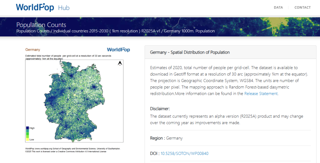
If you need population datasets to complement the Germany shapefiles, we recommend downloading WorldPop Germany.
Provides high-resolution population distribution estimates.
Useful for demographic analysis, urban planning, health research, and spatial modelling.
Data is delivered in GeoTIFF format and integrates seamlessly with shapefiles.
👉 Access here: WorldPop Germany (License: CC BY 4.0)
(License: CC BY 4.0)
Learn How to Use These Shapefiles
New to GIS? Don’t worry—our beginner-friendly guides will help you get started:
-
👉 How to Use Shapefiles in QGIS
Learn to import, style, and analyze shapefiles using this free, open-source GIS tool. -
👉 How to Use Shapefiles in ArcGIS
Explore how professionals use shapefiles in advanced mapping workflows.
Looking for More Shapefiles?
Our archive includes cleaned shapefiles for countries across the globe. Whether you’re working on a school project, academic research, or professional map visualization, we’ve got you covered.
👉 Browse our full shapefile archive here
Can’t find the country you need?
Contact us to request it.
We also welcome contributions—if you’ve cleaned shapefiles or derived GIS datasets, share them with us and help expand this global resource.

Idara Eniang is a passionate digital creator and geographer dedicated to making geography simple, visual, and accessible.


