![]()
Understanding the Geological Processes Behind Volcano Formation and Activity

Volcanoes are openings in the Earth’s surface where molten rock, gases, and ash escape from deep within the planet, driven by powerful tectonic and geological forces. Understanding the geological processes behind volcano formation and activity is essential because volcanoes shape landscapes, create valuable mineral resources, influence ecosystems, and pose significant hazards to communities across the world.
Beyond dramatic eruptions, volcanoes also play a role in long-term climate cycles by releasing gases that can warm or cool the atmosphere. This article breaks down everything you need to know, from how volcanoes form to why they behave differently, while also clearing up the often confusing classifications used in modern geography. We will explore the major types of volcanoes, the science behind their development, and real-world examples that demonstrate their impact on society and the environment.
What Is a Volcano?
A volcano can be defined as a natural opening in the Earth’s crust where molten rock (magma), gases, and ash escape from deep underground.
In simple terms, it is a vent that allows heat and pressure from the Earth’s interior to reach the surface. Scientifically, volcanoes form when magma rises from the mantle due to intense heat, buoyancy, and tectonic forces. They are most commonly found along plate boundaries, such as subduction zones, rift valleys, and mid-ocean ridges, but also occur at hotspots like Hawaii, where plumes of hot mantle material burn through the crust.
While our solar system has other volcanic bodies, Earth’s volcanoes are uniquely active because our planet has abundant internal heat, moving tectonic plates, and liquid water that affects magma formation. Understanding what is a volcano in geography helps explain not just eruptions, but also how volcanoes build mountains, create new land, and shape entire ecosystems.
How Volcanoes Are Formed: The Science Behind Eruptions
Volcanoes are more than dramatic natural features. They are windows into Earth’s internal activity. Their formation begins deep underground, where heat, pressure, and moving tectonic plates create pathways for molten rock to rise. Understanding how volcanoes form helps us explain why they appear in specific locations and why some eruptions are gentle while others are highly destructive.
Plate Boundaries and Magma Movement
Divergent boundaries (mid-ocean ridges)
At divergent plate boundaries, tectonic plates move apart, allowing molten rock from the mantle to rise and create new oceanic crust. This process forms long volcanic chains called mid-ocean ridges, where lava flows steadily and creates underwater volcanoes. The Mid-Atlantic Ridge is a classic example of this slow but continuous volcanic activity.
Convergent boundaries (subduction zones)
At convergent boundaries, one plate sinks beneath another in a process known as subduction. As the descending plate moves deeper, it melts and forms magma, which slowly rises toward the surface. Many of the world’s most explosive volcanoes, including those in the Pacific Ring of Fire, are found in these zones because the magma is rich in gas and silica.
Hotspots (Hawaii, Iceland)
Hotspots are volcanic regions not directly tied to plate boundaries. They form where mantle heat columns, often called plumes, bring hot material upward. As a tectonic plate moves over a hotspot, a chain of volcanoes can develop. Hawaii and Iceland are famous examples; Hawaii sits above a deep mantle plume, while Iceland combines hotspot activity with a divergent boundary, making it one of the planet’s most volcanically active regions.
Magma Formation
Heat, pressure, and melting
Magma forms when rocks deep inside the Earth melt due to high temperatures, changing pressure, or the addition of water. These factors lower the melting point of mantle rocks, creating pockets of molten material.
Role of mantle plumes
Mantle plumes bring unusually hot material upward from deep within the mantle. This added heat can melt surrounding rock and generate large volumes of magma that feed volcanic systems over long periods.
How magma rises through cracks
Once magma forms, it moves upward because it is less dense than the surrounding solid rock. It travels through cracks and fractures in the crust, sometimes collecting in underground reservoirs called magma chambers. If the pressure becomes strong enough, the magma continues to rise all the way to the surface.
💡 Want a clearer picture of where magma comes from?
Before it becomes lava at the surface, magma forms deep inside the Earth. To understand this process better, check out my recent post “Inside the Earth: A Simple Guide to Earth’s Crust, Mantle, and Core”, where I break down Earth’s internal layers in a simple, visual, and exam-friendly way.
👉 Read it here: Inside the Earth: A Simple Guide to Earth’s Crust, Mantle, and Core
What Causes an Eruption?
Gas buildup
Magma contains dissolved gases like water vapour and carbon dioxide. As magma rises, pressure decreases, and these gases expand. When gas pressure becomes too strong, it can force the magma upward, triggering an eruption.
Magma chamber pressure
As more magma enters a chamber, pressure builds. If the surrounding rock cannot hold the pressure, the magma will break through the crust and erupt. Earthquakes often occur just before eruptions because the rock is cracking and shifting.
Types of eruptions (explosive vs effusive)
Volcanoes erupt in different ways depending on the magma’s composition. Explosive eruptions occur when gas-rich, sticky magma traps pressure until it bursts violently. These can produce ash clouds, pyroclastic flows, and large explosions. Effusive eruptions, on the other hand, involve runny lava that flows smoothly from vents or fissures, forming broad shield volcanoes like those in Hawaii.
Understanding Volcano Types (Old vs Modern Classification): Clearing the Confusion
Many readers eventually notice a big gap between what they learned in secondary school and what modern geology actually teaches, and I was no exception. I carried the same “secondary school geology” knowledge straight into university, confidently, until my 200-level Geomorphology class humbled me 🤣.
I still remember the day our lecturer casually asked, “What are the types of volcanoes?” Without hesitation, the entire class responded in perfect unison: “Active, dormant, and extinct volcanoes.” We were proud. Confident. Very wrong.
The lecturer paused, smiled, and then delivered the academic equivalent of a plot twist: “That answer is incomplete.” Our reward? An assignment. “Go and research the real classification of volcanoes”.
That assignment completely changed how I understood volcanoes. Historically, volcanoes were indeed grouped into active, dormant, and extinct, a system that is still useful for describing volcanic activity status. However, modern geology goes much further. Today, scientists classify volcanoes based on their shape, eruption style, and magma composition, which provides a far more accurate picture of how they form and behave.
This is why modern textbooks now emphasize categories such as shield volcanoes, stratovolcanoes, cinder cones, and lava domes, terms that better reflect the science behind volcanic processes rather than just whether a volcano is “alive or asleep.
This expanded approach gives geologists a clearer picture of how volcanoes behave, how dangerous they are, and what landscapes they create. It also helps learners and researchers compare volcanic systems across the world. By providing the different types of volcanoes explained in simple terms, this guide bridges the gap between old-school geography and modern Earth science, ensuring you fully understand how volcanoes form and why they erupt differently.
Volcano Classification in Geography: Beyond Active and Extinct
Although this shift in volcano classification is rooted in geology, it is equally important in geography, particularly physical geography and geomorphology. Geographers are not only interested in how volcanoes form, but also where they occur, the landforms they create, and how they influence human activities and spatial patterns.
Classifying volcanoes by their shape and eruption style—such as shield volcanoes, stratovolcanoes, cinder cones, and lava domes—allows geographers to better analyze volcanic landscapes, hazard zones, settlement risks, and regional variations in volcanic activity. In this way, modern volcanic classification strengthens geographical analysis rather than replacing it.
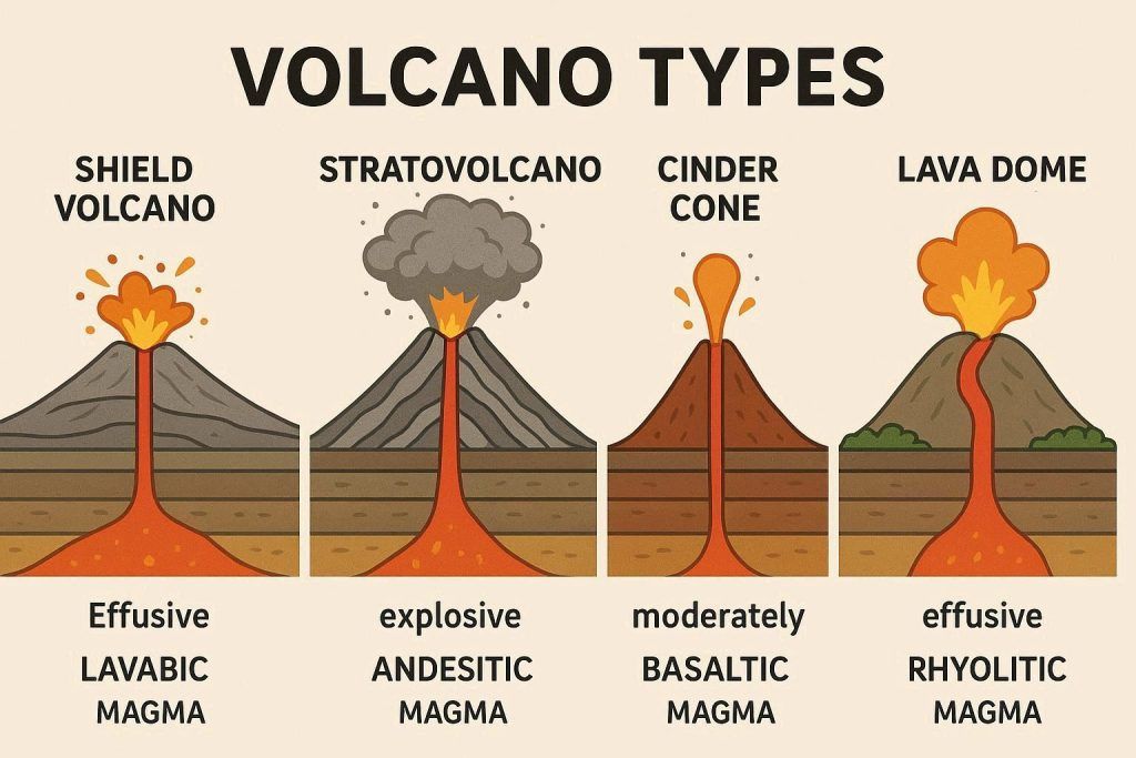
Types of Volcanoes
Now that the confusion around volcano classification has been cleared, we can move beyond the traditional labels of active, dormant, and extinct. Modern geography and geology focus on how volcanoes form, their shape, and the nature of their eruptions. With this approach in mind, let us explore the main types of volcanoes and the processes that create them.
- Shield Volcanoes: Shield volcanoes are broad, gently sloping volcanoes formed by the repeated flow of runny, low-viscosity lava that spreads easily over long distances. Because the lava is fluid, it cools slowly and builds wide, shield-like shapes rather than steep cones. These volcanoes usually form from basaltic magma and are associated with hotspots and divergent plate boundaries.Well-known examples include the volcanoes of Hawaii and Iceland, where lava flows accumulate over time to create massive volcanic landscapes. The formation of shield volcanoes involves frequent, non-explosive eruptions that gradually layer lava, making them among the largest volcanoes on Earth in terms of surface area.
- Stratovolcanoes (Composite Volcanoes): Stratovolcanoes, also known as composite volcanoes, are tall, steep-sided volcanoes built from alternating layers of lava, ash, and volcanic debris. Unlike shield volcanoes, their magma is usually thicker and richer in gases, which leads to explosive eruptions rather than gentle lava flows.These volcanoes are commonly found at convergent plate boundaries, especially in subduction zones. Famous examples include Mount Fuji in Japan and Mount St. Helens in the United States. Because of their violent eruption style, stratovolcanoes pose serious hazards, including ash fall, pyroclastic flows, and lahars, making them some of the most dangerous volcanoes on Earth.
- Cinder Cone Volcanoes: Cinder cone volcanoes are small, steep-sided, cone-shaped volcanoes formed from fragments of lava ejected into the air during short-lived eruptions. These fragments, known as cinders, ash, and volcanic bombs, fall back to the ground around the vent, gradually building a symmetrical cone.Because the material is loose and not well compacted, cinder cones often have steep slopes and a bowl-shaped crater at the summit. A well-known example is Parícutin in Mexico, which famously emerged in a farmer’s field in 1943 and grew rapidly over a few years. Cinder cone volcanoes are usually short-lived but provide clear evidence of volcanic activity at the Earth’s surface.
- Lava Domes: Lava domes are formed from thick, highly viscous lava that flows very slowly and does not travel far from the volcanic vent. Instead of spreading outward, the lava piles up near the opening, creating a rounded, dome-shaped structure. Lava domes grow gradually over time as successive layers of sticky magma are pushed upward.
Types of Volcanic Eruptions
- Effusive Eruptions: Effusive eruptions occur when magma contains low amounts of gas and is runny (low viscosity), allowing it to flow easily onto the Earth’s surface. Instead of explosions, lava pours out steadily, forming long lava flows and broad volcanic landforms.This type of eruption is commonly associated with shield volcanoes, such as those found in Hawaii, where lava can travel great distances before cooling. Although effusive eruptions are generally less dangerous, they can still cause damage by covering large areas with lava.
- Explosive Eruptions: Explosive eruptions happen when magma is thick, viscous, and rich in gas, preventing gases from escaping easily. As pressure builds within the magma chamber, it is released suddenly in violent explosions.These eruptions produce ash clouds, volcanic bombs, and fast-moving pyroclastic flows, which pose serious hazards to life and property. Explosive eruptions are commonly linked to stratovolcanoes and are responsible for some of the most destructive volcanic events in history.
- Phreatic and phreatomagmatic eruptions: This occurs when magma interacts with water, such as groundwater, lakes, or seawater. This contact causes the water to heat rapidly, turning to steam and creating violent explosions that eject ash, rock fragments, and steam.Unlike purely magmatic eruptions, these eruptions are driven by the sudden expansion of water rather than magma alone. A famous example is the 1883 eruption of Krakatoa, where the interaction between magma and seawater caused one of the most catastrophic volcanic explosions in recorded history.
Volcanic Materials and Landforms
Volcanic activity does more than produce eruptions; it also creates a wide variety of materials and landforms that shape Earth’s surface. The type of magma involved, the style of eruption, and the way volcanic materials are deposited all play a role in determining the landscapes we see in volcanic regions.
Lava Types (Basaltic, Andesitic, Rhyolitic)
Lava is commonly classified based on its silica content, which strongly influences its viscosity and eruption behaviour. Basaltic lava has low silica content, making it very runny and allowing gases to escape easily; this results in gentle, effusive eruptions. Andesitic lava contains moderate silica, giving it a thicker consistency and producing more explosive eruptions.
Rhyolitic lava is rich in silica, extremely viscous, and traps large amounts of gas, often leading to violent explosive eruptions. These differences explain why some volcanoes produce smooth lava flows while others generate powerful explosions.
Pyroclastic Materials
Pyroclastic materials are solid fragments ejected into the air during explosive volcanic eruptions. They vary in size and include volcanic ash (fine particles), lapilli (small rock fragments), and volcanic bombs (large blobs of molten or semi-molten rock).
Once expelled, these materials fall back to the surface, forming layers that can blanket landscapes, alter river systems, and pose serious hazards to nearby communities.
Major Landforms Created by Volcanoes
Volcanic activity creates some of the most distinctive landforms on Earth. Calderas form when a large eruption empties a magma chamber, causing the ground above to collapse. Lava plateaus develop from repeated outpourings of low-viscosity lava that spread over wide areas and solidify into flat landscapes.
Volcanic islands are formed when volcanic eruptions build up from the ocean floor until they rise above sea level, creating new land. Together, these landforms highlight the powerful role volcanoes play in shaping Earth’s surface.
Famous Volcanoes Around the World
Volcanoes are not only geological features, but they are powerful landmarks that tell unique stories about Earth’s internal processes, human history, and environmental impact. Around the world, certain volcanoes stand out because of their eruption style, location, or unusual magma composition. These examples highlight the diversity of volcanic activity across different regions of the planet.
- Mount Vesuvius is one of the most famous and dangerous volcanoes in the world. Located near Naples, it is best known for its catastrophic eruption in AD 79, which buried the Roman cities of Pompeii and Herculaneum. Vesuvius is a stratovolcano and remains active, posing a serious risk to nearby populations.
- Mauna Loa is the largest volcano on Earth by volume and surface area. It is a classic shield volcano formed by repeated effusive eruptions of basaltic lava. Its gentle slopes and frequent lava flows make it an important example of hotspot volcanism.
- Mount Etna is Europe’s most active volcano and one of the best-studied in the world. Located on the island of Sicily, Etna erupts frequently, producing lava flows, ash clouds, and volcanic gases. Its activity has shaped both the landscape and human settlement patterns in the region.
- Eyjafjallajökull gained global attention in 2010 when its eruption sent ash high into the atmosphere, disrupting air travel across Europe. This volcano lies beneath a glacier, making it a striking example of how volcanic activity can interact with ice and water to intensify eruption impacts.
- Nyiragongo is famous for its fast-flowing lava and persistent lava lake. Its low-viscosity lava can move rapidly, making eruptions especially dangerous for nearby communities, including the city of Goma. Nyiragongo demonstrates how magma composition directly affects volcanic hazards.
- Ol Doinyo Lengai is one of the most unusual volcanoes on Earth. Unlike most volcanoes, it erupts carbonatite lava, which is cooler, darker, and far less viscous than typical silicate lava. This rare characteristic makes Ol Doinyo Lengai a unique site for studying volcanic processes.

Volcanic Hazards and Their Impact
Volcanic activity can pose serious threats to both the natural environment and human societies. These threats, known as volcanic hazards, arise during eruptions and sometimes long after volcanic activity has ended.
Geographers and geologists classify volcanic hazards into primary hazards, which occur directly from an eruption, and secondary hazards, which are indirect effects triggered by volcanic activity. Understanding these hazards is essential for risk assessment, disaster preparedness, and land-use planning in volcanic regions.
Primary Hazards
Lava flows
Lava flows occur when molten rock pours out of a volcanic vent and moves across the land surface. While lava usually moves slowly enough for people to escape, it can destroy buildings, farmland, roads, and infrastructure in its path. Basaltic lava flows, common in shield volcanoes, can travel long distances before cooling, covering large areas.
Ash fall
Volcanic ash consists of tiny fragments of rock and glass blasted into the atmosphere during explosive eruptions. Ash fall can blanket vast regions, reducing visibility, contaminating water supplies, damaging crops, and causing respiratory problems. Heavy ash accumulation can also cause roofs to collapse and disrupt air travel, as seen in several modern eruptions.
Pyroclastic flows
Pyroclastic flows are among the most dangerous volcanic hazards. They are fast-moving currents of hot gas, ash, and volcanic debris that race down the slopes of a volcano at extremely high temperatures. These flows can destroy everything in their path within seconds, leaving little chance for survival.
Gas emissions
Volcanoes release gases such as carbon dioxide, sulfur dioxide, and water vapour. In high concentrations, these gases can be toxic, suffocate living organisms, or lead to acid rain. Carbon dioxide, being heavier than air, can accumulate in low-lying areas and pose a silent but deadly hazard
Secondary Hazards
Lahars (volcanic mudflows)
Lahars form when volcanic ash mixes with water from rainfall, melting snow, or glaciers. These thick mudflows can travel rapidly along river valleys, burying settlements far from the volcano itself. Lahars are especially dangerous because they can occur long after an eruption has ended.
Landslides
Volcanic activity can weaken slopes through earthquakes, explosions, or the accumulation of loose volcanic material. This instability can trigger landslides, which may block rivers, destroy infrastructure, and increase flood risk in surrounding areas.
Tsunamis
Volcanic eruptions that occur near or under large bodies of water can generate tsunamis. These may be caused by volcanic explosions, collapsing volcanic islands, or landslides entering the sea. Tsunamis can travel great distances and cause widespread coastal damage.
Climate impacts (aerosols and cooling)
Large explosive eruptions can inject volcanic aerosols and ash high into the atmosphere, where they reflect sunlight back into space. This can lead to short-term global cooling, altered rainfall patterns, and temporary climate changes. Such impacts demonstrate that volcanic hazards can extend far beyond local and regional scales.
Benefits of Volcanic Activity
Although volcanoes are often associated with destruction and danger, they also provide significant natural benefits that support ecosystems, human livelihoods, and long-term development. Over time, volcanic processes contribute to soil fertility, energy production, land creation, and the concentration of valuable resources. For geographers, understanding these benefits helps explain why many communities continue to live near active volcanoes despite the risks.
- Fertile soils
Volcanic soils are among the most fertile on Earth. When volcanic ash and lava break down through weathering, they release nutrients such as potassium, phosphorus, and calcium into the soil. These nutrients improve soil structure and water retention, making volcanic regions highly productive for agriculture. This is why areas around volcanoes often support dense populations and intensive farming. - Geothermal energy
Volcanic regions are important sources of geothermal energy, which is generated from heat stored beneath the Earth’s surface. This renewable energy can be used for electricity generation, heating, and industrial processes. Countries located along volcanic zones harness geothermal power as a clean and sustainable alternative to fossil fuels. - New land formation
Volcanic activity plays a key role in the creation of new land. Lava flows and volcanic eruptions can build land outward from coastlines or form entirely new islands when eruptions occur beneath the ocean. Over geological time, these processes have shaped continents and expanded Earth’s surface. When volcanic activity creates new islands, these fresh landscapes begin completely lifeless, setting the stage for plants and animals to arrive, compete, and establish ecosystems over time. Volcanic islands don’t just create land, they create new ecosystems from scratch.
What happens after new land rises from the ocean is just as fascinating as how it forms. Discover how life colonizes these fresh volcanic islands in our recent article on Island Biogeography.
- Valuable minerals
Many valuable minerals and ores are closely linked to volcanic and hydrothermal activity. Metals such as copper, gold, and silver often form when mineral-rich fluids circulate through volcanic rocks and later solidify. These resources are economically important and have influenced patterns of settlement, trade, and industrial development in volcanic regions.

How Scientists Study the geological processes behind volcano formation and activity
Yes, volcanoes are dangerous, but just like humans who are inexplicably drawn to chaos or keep finding themselves in obvious red-flag relationships, scientists can’t resist them. The high risks that make volcanoes destructive are the same reasons they are endlessly fascinating to study. Beneath the lava, ash, and explosions lie powerful clues about how the Earth works, how eruptions can be predicted, and how communities can be protected. This curiosity is what drives scientists to monitor, measure, and analyze volcanoes, sometimes from uncomfortably close distances.
Seismology
One of the most important tools used to study volcanoes is seismology, the study of earthquakes. Before many eruptions, magma moving underground causes small earthquakes as it forces its way through cracks in the crust. By analyzing earthquake patterns such as their frequency, depth, and location, scientists can detect magma movement and identify when a volcano may be becoming active.
Ground Deformation Monitoring
As magma rises and accumulates beneath a volcano, it can cause the ground to swell, tilt, or crack. Scientists monitor these changes using tools like GPS instruments and tiltmeters, which measure even tiny movements of the Earth’s surface. Detecting ground deformation helps scientists estimate magma buildup and assess the likelihood of an eruption.
Gas Monitoring
Volcanoes release gases long before lava reaches the surface. Monitoring gases such as sulfur dioxide (SO₂) and carbon dioxide (CO₂) provides valuable clues about what is happening underground. An increase in gas emissions often signals rising magma and increasing pressure, making gas monitoring a key method for early warning.
Remote Sensing
Modern technology allows scientists to study volcanoes from a safe distance using remote sensing techniques. Satellites equipped with thermal sensors can detect heat changes on a volcano’s surface, while high-resolution imagery helps track ash clouds, lava flows, and ground changes over time. Remote sensing is especially useful for monitoring volcanoes in remote or inaccessible regions.
Human Adaptation and Risk Reduction
While volcanoes are powerful and unpredictable, humans have developed strategies to adapt, reduce risk, and live safely in volcanic regions. Geographers and disaster scientists study both the natural processes of volcanoes and how communities interact with these hazards to develop effective risk management strategies. Through careful planning, monitoring, and education, people can minimize the dangers associated with living near active volcanoes.
- Early warning systems
Modern volcano monitoring allows scientists to detect signs of an impending eruption, such as increased seismic activity, gas emissions, and ground deformation. Early warning systems use this data to alert local communities in advance, giving residents crucial time to prepare or evacuate, which has saved countless lives in recent decades. - Hazard mapping
Hazard maps identify areas most likely to be affected by lava flows, ash fall, pyroclastic flows, and lahars. By visualizing the zones of greatest risk, authorities and planners can guide land use, restrict development in high-risk areas, and inform emergency preparedness strategies for vulnerable populations. - Evacuation planning
Even with monitoring and hazard maps, eruptions can be sudden. Well-designed evacuation plans are essential for moving people safely away from danger zones. This includes designated evacuation routes, shelters, communication strategies, and public education to ensure residents know what to do in case of an emergency. - Building resilience in volcanic regions
Long-term adaptation involves strengthening the resilience of communities through education, infrastructure planning, and sustainable development. Building materials and designs can reduce damage from ash or lava, while community programs teach residents how to respond effectively. Combining scientific monitoring with local knowledge helps societies coexist safely with these awe-inspiring natural features.
In conclusion, understanding volcanoes is more than memorizing names or famous eruptions; it’s about appreciating the geological processes behind volcano formation and activity and how these processes shape Earth’s landscapes, hazards, and resources. By studying volcanoes, we gain insights into plate tectonics, mountain building, earthquakes, and other dynamic Earth systems. Ready to test your knowledge? Take my Volcano Quiz and see how much you’ve learned about these fascinating natural phenomena!
External Sources & References
-
US Geological Survey (USGS) – Volcano Hazards Program
https://www.usgs.gov/programs/VHP
Authoritative source on volcano formation, eruption types, hazards, and monitoring. -
Smithsonian Institution – Global Volcanism Program
https://volcano.si.edu
Comprehensive database of active and dormant volcanoes worldwide. -
British Geological Survey (BGS) – Volcanoes and Plate Tectonics
https://www.bgs.ac.uk/discovering-geology/earth-hazards/volcanoes
Clear explanations linking volcanism to plate boundaries and hotspots. -
National Geographic Society – Volcano Education Resources
https://education.nationalgeographic.org/resource/volcano
Student-friendly explanations, diagrams, and real-world examples. -
NASA Earth Observatory – Volcanoes and Earth Systems
https://earthobservatory.nasa.gov/topic/volcanoes
Satellite imagery and insights into volcanic impacts on climate and landscapes. -
Encyclopaedia Britannica – Volcano
https://www.britannica.com/science/volcano
Concise scientific definitions and classifications.

Idara Eniang is a passionate digital creator and geographer dedicated to making geography simple, visual, and accessible.